Friday, June 08, 2007

Weymouth


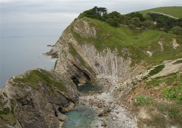
Following the eyeline to the east of Weymouth provides interesting walking and beaches with unusual features. The coast is made up of complex sequences of rocks, which have been jumbled up by geological folds and faults

The cliffs here are formed from Upper Jurassic clays, limestones and sandstones

Source

Text: The Official Guide to the Jurassic Coast

Saturday, June 02, 2007

Through the Trees to Charmouth

Charmouth is a Gateway Town, but is located very close to the shoreline

The rocks at Charmouth are 195 million years old and from the Jurassic geological period. Charmouth covers the area from Black Venn in the West to Stonebarrow in the East. Black Venn was the scene of the largest mudslide in Europe during the winter of 1958 / 59 and Stonebarrow is the scene of occasional cliff falls


Settlement of Charmouth began in the early Iron Age by a Celtic tribe known as the Durotriges. Evidence of thier impressive hill-forts survive today in the surrounding area. the most notable being Maiden Castle, sacked by the Romans in around AD47

Charmouths first claim to fame came in the years 833 and 840 when the Wessex kings Ethelred and Ethelwolf unsuccessfully tried to repel Viking invaders. Eventually the Vikings settled peacefully among the local population. The community living on the bank of the River Cerne. The village 'Cernmunde' was recorded in the Doomsday book of 1088

In 1501 catherine of Aragon stayed in the village on her way to marry Arthur, brother of Henry VIII. Charles II is reputed to have sheltered here after his escape from the Battle of Worcester in 1651

Currently it has a population of about 1200

Sunday, April 08, 2007

Westbay - East Cliffs


The West Dorset coast frome Lyme Regis to Burton Bradstock is a beautifull landscape of cliffs and landslides - sudden landslides cause the the pathways to be diverted slightly inland in the name of safety. The above picture is of the East Cliffs of Westbay

The cliffs are formed by erosion acting over time and by landslides that occur during wet years. Global warming and a rising sea-level will ensure that these processes will continue

Thursday, January 11, 2007

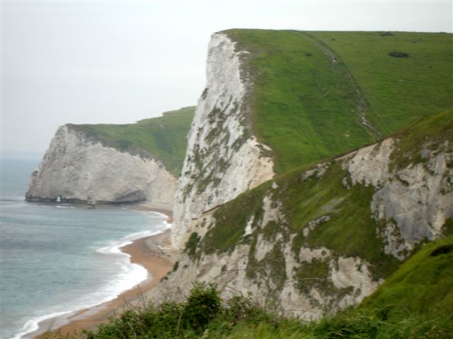
The Cliffs between Lulworth Cove and Durdle Door


This photograph clearly shows the chalk of the Certatious era and is one of the youngest rock types to be seen on the Jurassic Coast. Chalk is a soft, very finely grained limestone formed from a 'mud' of calcium carbonate, often made up of the shells of tiny marine organisms

These cliffs, Durdle Door and Lulworth Cove can be seen to thier best advantage from the sea, on boat trips from Lulworth and Weymouth

For information there is a Heritage Centre at Lulworth Cove

Tuesday, January 09, 2007

Lyme Bay

Monday, December 25, 2006

Swanage


The hard banks of limestone form headlands while softer clays have been eroded into bays. Boat trips offer a fabulous view of the 80 million year old chalk stacks of Old Harry Rocks, the most easterly end of the Jurassic Coast. At Ballard Down the chalk ridge appears and the almost vertical layers of the chalk can only be seen from the sea. At one time, the ridge ran right across to the needles on the Isle of Wight

There is a Heritage Centre at Swanage and boat trips are available to Poole Harbour

Wednesday, December 20, 2006

Monday, December 18, 2006

Friday, December 15, 2006

World Changes during the Triassic, Jurassic and Cretatious Era's


The super-continent of Pangea

During the Triassic era, 240 million years ago, one hemisphere was dominated by a vast ocean while the other hemisphere was dominated by a great super-continent. Pangea. This great landmass included all of what is now known as North America, Europe, North Asia. Africa, South America, India, Australia and Antartica

During Triassic times, Pangea moved gradually northwards. At the end of the permian period, very low sea levels and climate change coincided with a major extinction event. Since then sea levels have risen again allowing a slow recovery of marine life such as corals on land - tropical coal forming forests and swamps diminished as climates got warmer and drier

During the Jurassic era, 170 million years ago, the world was a warmer, less varied place than it is today. There were probably no ice caps at the poles for much of this time. The mild conditions made for much higher sea levels resulting in a smaller area of dry land but extensive shallow continental seas, which teemed with life.

The huge continent of Pangea was splitting up, and familiar modern landmasses such as North America and Eurasia were begginning to appear. Both the North and South Atlantic oceans began to open up. At the same time the ancient tethys ocean began to close

The Cretatious period spanned almost 80 million years from 142 million to 65 million years ago. During this time the world began to take on a familiar look as lands that had once made up the super-continent of Pangea pulled apart. The newly formed Atlantic Ocean extended north and southwards, seperating Africa and Eurasia from the Americas. The continents of Africa, India, Antartica and Australia began to move apart about 120 million years ago as new oceans formed between these constiuents of ancient Gondwana. Asia still had an unfamilliar form, with lands that are now part of its southern edge, such as Indochina and India, still seperate islands.

By about 90 million years ago, the distribution of the contients was looking more familiar. The Atlantic ocean seperated the new world of of the Americas from the old world of Europe, Asia, and Africa. Much of Asia was assembled, except for India. Australia still languished in the deep south, attached to Antartica and India was still attached to Madagascar

Source: The Atlas of the Prehistoric World and Wikipaedia

Monday, December 11, 2006

Budleigh Salterton

Budleigh Salterton has one of the oldest stories of the Jurassic Coast. A story that is also spread out along the length of this coast and beyond

To the west of the sea front lie the famous Budleigh Salterton Pebble Beds. The pebbles are composed of hard quartzite identical to 440 million year old rocks found in Northern France. The pebbles were formed and transported in one of the giant rivers that flowed into the Triassic desert about 240 million years ago

Over the last few thousand years the pebbles have been falling from the cliffs and today form the bulk of the beach at Budleigh Salterton. The larger cobbles and pebbles are very hard and unlike any other rock type found in Southern England. As a result they survive as they are transported along the coast by the waves. They can be seen from Slapton Sands in Devon to Hastings in Sussex

Source: The Official Guide to the Jurassic Coast

Saturday, December 09, 2006

Durdle Door


Thursday, November 30, 2006

Charmouth: The Pebbles


Source: www.bbc.co.uk

Saturday, November 25, 2006

Beer, Devon


Source: Photograph taken by Mark Whitworth and courtesy of the BBC

Thursday, November 23, 2006

The Rock beneath our feet!

Rock can be broadly classified into three types. Igneus, metamorphic and sedimentary, with the Jurassic Coast being of the sedimentary type

Igneus, is the rock that originates from magma within the earth's crust, produced by volcanic activity, when it is found on the earths surface
Metamorphic is the rock that is transported into the depths of the earth by geological processes, where it is heated and compressed. This process eventually changes its composition

Sedimentary rock is created by processes that occur on the surface of the earth, by the weathering of existing rock by water, ice and wind. Sedimentary rocks may consist of the organic remains of marine organisms (limestone), land plants (coal) or chemical reactions and evaporation (salt). Sedimentary rocks that constitute the Jurassic Coast are formed largely of the remains of marine animals. Sedimentary rock is often created by the weathering and re-deposition of pre-existing rock, with the parent rock being of igneus, metamorphic or sedimentary type. Rock particles, once created, are generally carried to distant locations by water, wind or ice, before sedimentation occurs

In past times of high sea levels, shallow seas have flooded deep inland and produced vast continent-wide limestone deposits. Chalk is a form of limestone, that developed in the Cretatious era. This rock was formed by millions of tiny plates of single-celled microorganisms called coccoliths. Over a few million years thier calcite plates piled up on the seabed to form a carbonate mud, which is now a form of limestone, up to 300 metres thick. This chalk forms the spectacular white cliffs of Southern England and North Western France

Any fossil content within a sedimentary rock will indicate its age and the type of environment in which it was deposited. Sedimentary rock often contains organic and inorganic materials. For example, early Jurassic black mudstone, found in the cliffs of Lyme Regis, contains organic material in the form of fish teeth and ichthysaurus bones. The mud itself is made of small inorganic rock particles, but its black colour suggests a high carbon content, the result of decomposition of the soft parts of organisms

Most sediment is deposited underwater, and is then buried further before it becomes rock. The exposure of marine sediment above sea level is due either to tectonic plate processes such as earthquakes and volcanic activity or to a general decrease in sea levels such as is associated with glaciation. Once sedimentary rock is exposed, weathering begins, particles are transported, and the cycle begins again

Tuesday, November 21, 2006

Saturday, November 18, 2006

Fossils on the Jurassic Coast

Fossils are the remains of animals and plants that have been preserved in stone and are the raw materials of the science of paleantology. Paleantology looks at the the direct evidence of fossils to study former life on earth and how it has changed over millions of years

The rocks that form the cliffs of Charmouth and Lyme Regis are rich in those animals that swam in the seas during the Jurassic period. As a result of landslides and winter storms, the area is rich in fossils that have been washed onto the beach. These fossils represent one of the richest snapshots of Jurassic life anywhere in the world

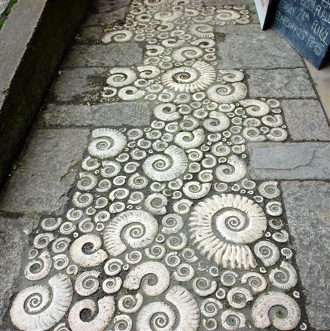
Geologists use fossils to help them identify rocks of a similar age, as rocks located hundreds of miles apart can be recognised as being of a similar age, according to the fossils that they contain. Ammonites are especially useful for this purpose as they evolved and changed rapidly (in geological terms), producing different species with distinctive shell forms. The Jurassic period has been dived into a series of Zones according to the appearance and disappearance of different ammonites


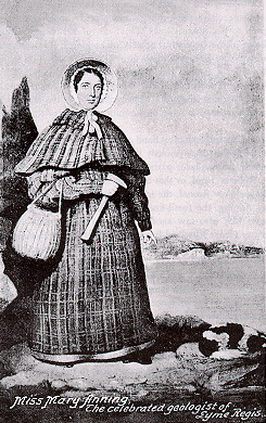
Mary Anning: courtesy of Wikipedia

Mary Anning (1797 - 1847) lived all her life in Lyme Regis and has been described as 'the greatest fossilist who ever live'. She collected fossils at a time when scientific enquiry was leading to a change in the way we thought about the evolution of life and our planet, which would culminate with the puplication of Charles Darwin in 'On the Origin of Species'

Mary collected fossils with her brother and father until the death of her father when she was aged 11. Mary took on the family business, becoming one of the most skilled of collectors, with an impressive knowledge of Anatomy. Her record of fossil 'firsts' is remarkable, leading to many eminent geologists of the day visiting the coast to learn from her work


Source: text
S0urce: graphics

Thursday, November 16, 2006

Lulworth Cove and Stair Hole


The coast around Lulworth Cove demonstates all stages in the development of bays and headlands, and how that development is controlled by the underlying geology. Along this section of the coast, the rocks have been tilted into a near vertical position

The oldest rocks, Portland Limestone, provides a barrier to the sea, behind which are progressively softer rocks, Purbeck Limestone, Lower Greensand, Wealdon Clay and Upper Greensand. The youngest rocks are chalk, which although soft are massive in thickness

The river that runs into the cove at one time reached the sea, through a cut in the hard Portland Limestone barrier. This allowed the sea to erode the Limestone. Once the sea reached the softer rocks behind, especially the Wealdon Clay, rapid erosion took place. Once the sea reched the chalk, erosion slowed, forming the perfect bay

To the west, the sea has been eroding the Portland Limestone at Stair Hole and the process of bay formation has just begun. Eventually lulworth Cove and Stair Hole will form one larger cove

Source: text

Wednesday, November 15, 2006

The Ammonite Path

Saturday, November 11, 2006

Gateway-Towns - Lyme Regis


The Jurassic Coast by its very nature is 95 miles long, but only a few metres wide. It is served by a handfull of towns, known as gateway towns. They are located very close to the Coast, providing serves for visitors such as hotels, guest-houses, restaurants, shopping facilities, museams and information


The clay cliffs around Lyme Regis are about 200 million years old, marking the start of the Jurassic period, capped by sandstone of about 100 million years in age. After heavy winter rains, huge mudslides flow onto the beach, where they are washed away by rough seas, uncovering the fossils

Lyme Regis is served by a Tourist Information Centre and Museum. You can also take boat trips from here, enabling the viewing of the Jurassic Coast from the sea, possibly the best way to see it

Saturday, November 04, 2006

Old Harry!


Silently Sleeping is the rock formation known as Old Harry's Rocks, located on the extreme South east of the Jurassic Coast